Maintenance for the week of May 4:
• PC/Mac: No maintenance – May 4
• PC/Mac: No maintenance – May 4
Vvardenfell Region Map

Enodoc
✭✭✭✭✭
✭✭✭✭✭
✭✭✭✭✭
There is no indication in-game of where the borders between the geographical regions of Vvardenfell are situated, so I went ahead and created my own map, based on landscape features and climate patterns.
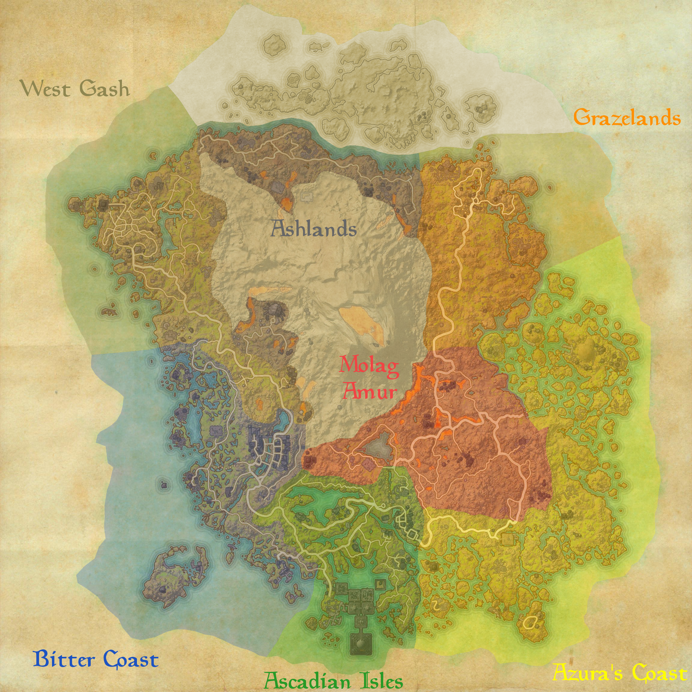
Now some of you may be thinking "That's not how it was in TES3!", and you'd be correct. That is entirely intentional. I'll call out some of the more notable differences below, but I'd also love some input from @Lawrence_Schick and @ZOS_ZebCook as to whether I'm close to the mark with my map.
Edited by Enodoc on May 22, 2017 2:34PM Now some of you may be thinking "That's not how it was in TES3!", and you'd be correct. That is entirely intentional. I'll call out some of the more notable differences below, but I'd also love some input from @Lawrence_Schick and @ZOS_ZebCook as to whether I'm close to the mark with my map.
- Balmora - Due to the differences in vegetation by being 700 years in the past, and what that surrounding vegetation actually comprises, I've put Balmora in the Bitter Coast instead of the West Gash for this time period. (The same goes for Shulk Mine, Rethan Manor, and Vassir-Didanat, which would fit better into Bitter Coast than Ascadian Isles by position, since there's a ridge of land that I could use as a border.)
- Molag Mar - Again, the surrounding area is much more green than it will be in 700 years time, and it matches the ladscape of Azura's Coast more than it does Molag Amur.
- Tel Mora - There appears to be much less of a divide between Vos and Tel Mora (both politically and physically), as they seem to basically be two parts of the same settlement, so I extended the Grazelands to include the island that would be part of Azura's Coast in the future. (And also Esutanamus, for cohesion, so then I could mark the northern edge of Azura's Coast by the northern edge of Zafirbel Bay.)
UESP: The Unofficial Elder Scrolls Pages - A collaborative source for all knowledge on the Elder Scrolls series since 1995
Join us on Discord - discord.gg/uesp
Join us on Discord - discord.gg/uesp
22
-
 Aliyavana✭✭✭✭✭
✭✭✭✭✭There is no indication in-game of where the borders between the geographical regions of Vvardenfell are situated, so I went ahead and created my own map, based on landscape features and climate patterns.
Now some of you may be thinking "That's not how it was in TES3!", and you'd be correct. That is entirely intentional. I'll call out some of the more notable differences below, but I'd also love some input from @Lawrence_Schick and @ZOS_ZebCook as to whether I'm close to the mark with my map.- Balmora - Due to the differences in vegetation by being 700 years in the past, and what that surrounding vegetation actually comprises, I've put Balmora in the Bitter Coast instead of the West Gash for this time period. (The same goes for Shulk Mine, Rethan Manor, and Vassir-Didanat, which would fit better into Bitter Coast than Ascadian Isles by position, since there's a ridge of land that I could use as a border.)
- Molag Mar - Again, the surrounding area is much more green than it will be in 700 years time, and it matches the ladscape of Azura's Coast more than it does Molag Amur.
- Tel Mora - There appears to be much less of a divide between Vos and Tel Mora (both politically and physically), as they seem to basically be two parts of the same settlement, so I extended the Grazelands to include the island that would be part of Azura's Coast in the future. (And also Esutanamus, for cohesion.)
Should do a political map based on which houses control where in this time period1 -
Enodoc✭✭✭✭✭
✭✭✭✭✭
Yeah that could be interesting. Political borders are harder to identify since they don't have geographical features marking the edges. But for the most part you could just say that everything in the Ascadian Isles, Bitter Coast, and West Gash is Redoran (except Vivec City and Seyda Neen), and everything in Azura's Coast and the Grazelands is Telvanni (except Molag Mar). Everything else is unclaimed.Should do a political map based on which houses control where in this time periodEdited by Enodoc on May 22, 2017 2:39PMUESP: The Unofficial Elder Scrolls Pages - A collaborative source for all knowledge on the Elder Scrolls series since 1995
Join us on Discord - discord.gg/uesp0 -
 altemriel✭✭✭✭✭
✭✭✭There is no indication in-game of where the borders between the geographical regions of Vvardenfell are situated, so I went ahead and created my own map, based on landscape features and climate patterns.
Now some of you may be thinking "That's not how it was in TES3!", and you'd be correct. That is entirely intentional. I'll call out some of the more notable differences below, but I'd also love some input from @Lawrence_Schick and @ZOS_ZebCook as to whether I'm close to the mark with my map.- Balmora - Due to the differences in vegetation by being 700 years in the past, and what that surrounding vegetation actually comprises, I've put Balmora in the Bitter Coast instead of the West Gash for this time period. (The same goes for Shulk Mine, Rethan Manor, and Vassir-Didanat, which would fit better into Bitter Coast than Ascadian Isles by position, since there's a ridge of land that I could use as a border.)
- Molag Mar - Again, the surrounding area is much more green than it will be in 700 years time, and it matches the ladscape of Azura's Coast more than it does Molag Amur.
- Tel Mora - There appears to be much less of a divide between Vos and Tel Mora (both politically and physically), as they seem to basically be two parts of the same settlement, so I extended the Grazelands to include the island that would be part of Azura's Coast in the future. (And also Esutanamus, for cohesion, so then I could mark the northern edge of Azura's Coast by the northern edge of Zafirbel Bay.)
nice!! thank you!!0 -
Enodoc✭✭✭✭✭
✭✭✭✭✭And of course if anyone notices that anything's wrong, or has some other suggestions, those are welcome too!UESP: The Unofficial Elder Scrolls Pages - A collaborative source for all knowledge on the Elder Scrolls series since 1995
Join us on Discord - discord.gg/uesp0 -
Enodoc✭✭✭✭✭
✭✭✭✭✭I tweaked the border around Nchardumz. This ruin is now within Molag Amur, since it has the Molag Amur weather effects.UESP: The Unofficial Elder Scrolls Pages - A collaborative source for all knowledge on the Elder Scrolls series since 1995
Join us on Discord - discord.gg/uesp0 -
 quadraxis666✭✭✭✭✭
✭As a British person, Reading the word Gash caused more laughter than would be considered appropriate.3 -
 Dyride✭✭✭✭✭Where's my Sheogorad?V Є H Є M Є И C Є
Revenge of the Bear
ØMNI
Solongandthanksforallthef
Revenge of the Hist
Revenge of the Deer
Remember the Great Burn of of the Blackwater War!
#FreeArgonia0 -
 O_LYKOS✭✭✭✭✭
✭If you don't quote the original thread post what happens? Some people quote, some don't. Is it necessary?
PC NA - GreggsSausageRoll0 -
 Ignotus✭✭✭
Completely unnecessary imo, especially when the OP is really long or contains graphics. If you don't quote a later post in the thread, then I always just assume you are responding in regards to the OP. Never understood why people do it. Pet peeve of mine, but I try not to say anything about it typically.If you don't quote the original thread post what happens? Some people quote, some don't. Is it necessary?1 -
Enodoc✭✭✭✭✭
✭✭✭✭✭
Since you can't actually get there, I greyed it out. Same with the majority of the Ashlands/Red Mountain area.Where's my Sheogorad?UESP: The Unofficial Elder Scrolls Pages - A collaborative source for all knowledge on the Elder Scrolls series since 1995
Join us on Discord - discord.gg/uesp0

