Maintenance for the week of May 11:
• PC/Mac: No maintenance – May 11
• PC/Mac: No maintenance – May 11
Map of Tamriel with scale

Llevndryn
✭✭✭
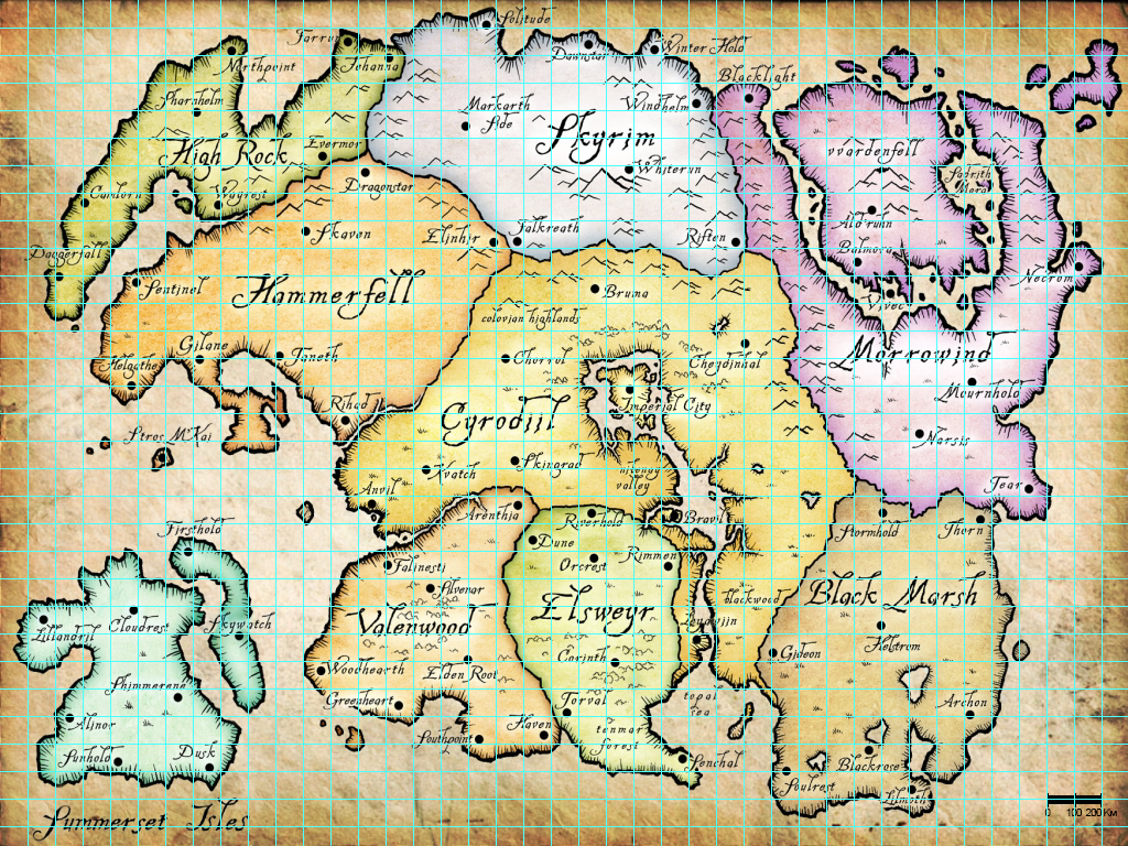
I made this map of Tamriel with scale based on TopalthePilot calculations on this post on reddit.
Each square is 10000km^2 , 100 kilometers for a side.
One day by horse was approxymatly 50 to 100 kilometers for a courrier during Middle Ages, so one square would be one or two days of travel.
Addressing discrepancies in Tamriel's scale
Using the PGE1 Morrowind source for 250 mi (402 km), I managed to get the distance to line up with both the Arena and Daggerfall scale depending how you look at it.
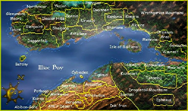
Let's start with Daggerfall. Using this map and the accepted scale of 161,600 km2 I managed to figure out the map is 523 x 309 km (325 x 192 mi). Using these figures I measured the distance between Betony and the Isle of Balfiera to be approximately 283 km (176 mi). Now let me take you back to the PGE. In the Vvardenfell section it says: "On a clear day (an exceedingly rare event), the peak can be seen from Almalexia, 250 miles to the south." If we take that to mean the distance from the peak to Almalexia then the scale stated matches up almost perfectly with Daggerfall's scale. However, using this scale, the distance east to west (Necrom to Daggerfall) ends up being 2000 km (1243 mi). Seems a bit small doesn't it?
Moving on to Arena. As stated on page 55 of the Arena Manual "The world of Tamriel is vast, roughly three to four thousand kilometers east to west and two to three thousand kilometers north to south." Personally, I like these distances much more, but are they backed up? Let's say instead of the 250 mile distance being from the peak of Red Mountain to Almalexia, the PGE was referring to Vvardenfell as a whole and that the distance is actually from Almalexia to Vvardenfell's shore. Taking the average distance to the shore, we find that the new scale makes Tamriel 3750 km (2330 mi), which is between 3 and 4 thousand, like stated in the Manual.
After scouring the Imperial Library and finding several other possible distances, none of them were specific enough or able to be accurately measured on a map. Such as the Redguard dialogue and the distance between Lilmoth and the southern shore of Black Marsh. Due to this, the Arena and Daggerfall scales are the only ones I could find matching evidence with.
Just for fun I used Google Earth Pro (which I found was free thanks to /u/sd51223) to find the approximate area of each province based on the Arena scale:
Using the PGE1 Morrowind source for 250 mi (402 km), I managed to get the distance to line up with both the Arena and Daggerfall scale depending how you look at it.
Let's start with Daggerfall. Using this map and the accepted scale of 161,600 km2 I managed to figure out the map is 523 x 309 km (325 x 192 mi). Using these figures I measured the distance between Betony and the Isle of Balfiera to be approximately 283 km (176 mi). Now let me take you back to the PGE. In the Vvardenfell section it says: "On a clear day (an exceedingly rare event), the peak can be seen from Almalexia, 250 miles to the south." If we take that to mean the distance from the peak to Almalexia then the scale stated matches up almost perfectly with Daggerfall's scale. However, using this scale, the distance east to west (Necrom to Daggerfall) ends up being 2000 km (1243 mi). Seems a bit small doesn't it?
Moving on to Arena. As stated on page 55 of the Arena Manual "The world of Tamriel is vast, roughly three to four thousand kilometers east to west and two to three thousand kilometers north to south." Personally, I like these distances much more, but are they backed up? Let's say instead of the 250 mile distance being from the peak of Red Mountain to Almalexia, the PGE was referring to Vvardenfell as a whole and that the distance is actually from Almalexia to Vvardenfell's shore. Taking the average distance to the shore, we find that the new scale makes Tamriel 3750 km (2330 mi), which is between 3 and 4 thousand, like stated in the Manual.
After scouring the Imperial Library and finding several other possible distances, none of them were specific enough or able to be accurately measured on a map. Such as the Redguard dialogue and the distance between Lilmoth and the southern shore of Black Marsh. Due to this, the Arena and Daggerfall scales are the only ones I could find matching evidence with.
Just for fun I used Google Earth Pro (which I found was free thanks to /u/sd51223) to find the approximate area of each province based on the Arena scale:
- High Rock - 530,000 km2 (Yemen)
- Skyrim - 1,000,000 km2 (Egypt)
- Morrowind - 1,600,000 km2 (Mongolia)
- Hammerfell - 1,000,000 km2 (Egypt)
- Cyrodiil - 1,850,000 km2 (Sudan)
- Summerset Isles - 735,000 km2 (Zambia)
- Valenwood - 663,000 km2 (Afghanistan)
- Elsweyr - 635,000 km2 (Somalia)
- Black Marsh - 1,070,000 km2 (Bolivia)
- Tamriel's area would total around 9,083,000 km2.
9